Snow Forecast overload
Snow forecast websites have proliferated in recent years, taking weather feed data and processing it to produce sometimes wildly erroneous predictions. Of course the more snow predicted the more a forecast grows legs and drives traffic, clics and revenue back to the forecasting site. The raw data computer generated sites that don’t filter their information with some human assessment are usually the worst offenders, but human intervention can also mean more exaggeration, or simple error.
If you actually live somewhere for the whole season and monitor the predictions vs the reality you get a good idea how reliable a site is.
Snow-forecast.com are one of the longest established forecast sites, with the widest geographic distribution of areas – even for countries/places with no actual ski lifts they’ll give a forecast. I discovered the site back in 2004 when guiding a group tour round South America in a woeful season. We flew up from Ushuaia, which is like another island south of New Zealand or 3 Tasmania’s south of Australia, and the jump off point for Antarctica cruises, where it was weirdly warm, to find Las Leñas had closed in late August for lack of snow. We had a week there with the group, but what to do? Snow-forecast predicted a massive dump that would be more than enough for a re-opening, so we held off cancelling everything and it came through. We got there Saturday night, the lifts re-opened Monday, and we had waist deep snow with hardly any competition till thursday when more people arrived.
Over 11 seasons at Cerro Catedral monitoring the site closely they generally predict big dumps reasonably well, often under-estimating the snow line, while often over-estimating smaller falls.
For Australia the same seems to be the case for most sites – e.g. some were predicting 25cm from last week’s falls, which turned out to be well over the top. But hands up who got excited and shared something out about it?
Snowatch is the other major Australian forecast site along with MountainWatch, and owner Pete ‘The Frog’ Taylor puts his human input into things so the predictions are hype free, and for a good idea what might happen in next couple of weeks his longer term forecasts are a great general guide that get honed down in accuracy as the timeline closes in.
Australias’s Bureau of Meteorology does an excellent job, and their site is well worth bookmarking too.
Of course with the proliferation of webcams the simplest thing to do is bookmark your favourites and check them for up to the minute and to see if the forecasts are being fulfilled – a difference of 1° can mean rain or snow, and make a huge difference.
But the bottom line is unless you are doing a season to poke your head out the door or ski into the gloom to find out, all the prediction in the world won’t guarantee you get the goods. Mountain weather is fickle, the snow can be great but the wind too high for lifts or whatever. So maybe we should all be less choosy and take what we get.
Right now NZ is looking good for great early season conditions, with a natural base topped by snowmaking, while Australia will be snowmaking dependent for the next couple of weeks. Does that mean you are guaranteed anything booking either one in July? If you have to book a trip on your available time-off dates worrying too much about forecasts and conditions weeks out is a waste of time.
Here are the forecasts at 11am monday morning 6 June from the big 3 – MountainWatch reckon Mt Selwyn will get 20cm in next 3 days, more than anywhere else in Australia; Snowatch says none and Snow-forecast says a few cm snow for Perisher and fair bit of rain.
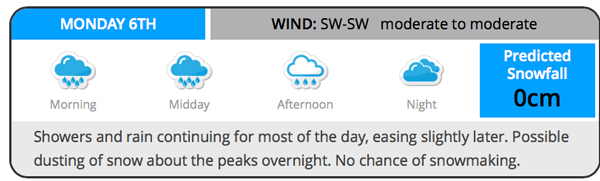
0cm says Snowatch
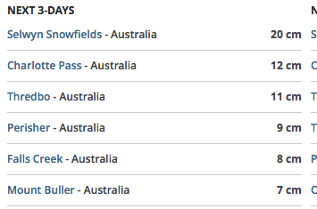
Mountainwatch calling 20cm for Selwyn and 7cm for Perisher next 3 days
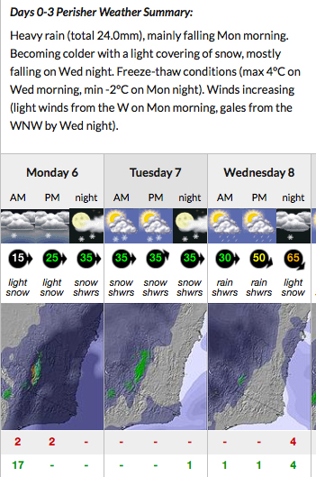
Snow-forecast calling a few cm snow and more rain